
|
| You might also like: | Libya | Tunisia | Somalia | Nigeria | Somalia - Follow the Instructions | Today's featured page: All About Gorillas |
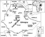
Capital: Addis Ababa is the capital of Ethiopia.
Size: Ethiopia covers about 1,104,300 square kilometers (almost twice as big as the state of Texas). Ethiopia is the 27th largest country in the world.
Population: The people of Ethiopia are called Ethiopians. Ethiopia has the 14th largest population of any country in the world. The population of Ethiopia is about 88,013,491 (as of July, 2010).
Government: Ethiopia is a federal republic that is divided into 9 ethnically based states and 2 self-governing administrations. Ethiopia's national holiday is National Day, celebrated on May 28 (marking the defeat of the Mengistu regime on May 28, 1991).
Language: The official national languages are Amarigna (Amharic), English, and Arabic.
Education: Girls in Ethiopia go to school for an average of 8 years; boys in Ethiopia go to school for an average of 9 years.
Literacy Rate: About 42.7% (under half) of the adults in Ethiopia can read and write. About 50.3% of the men and 35.1% of the women are literate.
Religion: Orthodox 43.5%, Muslim 33.9%, Protestant 18.6%, traditional 2.6%, Catholic 0.7%, other 0.7%.
Major Rivers: The Blue Nile (the source of the Blue Nile, Lake Tana, is in Ethiopia).
Terrain/Mountain Ranges: High plateau with central mountain range divided by the Great Rift Valley.
Highest Point: The highest point in Ethiopia is Ras Dejen, which is 4,533 m above sea level; it is located in northwestern Ethiopia (near the Eritrean border).
Lowest Point: The lowest point in Ethiopia is Danakil Depression, at 125 m below sea level; it is located in northeastern Ethiopia (near the Eritrean border).
Natural Resources: small reserves of gold, platinum, copper, potash, natural gas, hydropower.
Major Industries: food processing, beverages, textiles, leather, chemicals, metals processing, cement.
Agricultural Products: cereals, pulses, coffee, oilseed, cotton, sugarcane, potatoes, qat, cut flowers; hides, cattle, sheep, goats; fish.

Ethiopia's FlagEnchantedLearning.com
All About Ethiopia
Outline Map Printout
Location: Ethiopia (officially called the Federal Democratic Republic of Ethiopia) is a landlocked, poverty-stricken country in eastern Africa. Ethiopia is bordered by Somalia, Kenya, Sudan, Eritrea, and Djibouti.

 Ethiopia's Flag: The flag of Ethiopia is a tricolor with three equal horizontal bands of green (top), yellow, and red. In the center is a pale blue circle containing a yellow five-sided star with five yellow rays (one between each of the arms of the star). The green in the flag symbolizes hope and the fertility of the land; yellow represents justice and harmony; red stands for sacrifice and heroism; pale blue symbolizes peace and the star represents the unity and equality of all the people of Ethiopia.
Climate: Tropical monsoon with wide variations based on terrrain.
Related Activities and Printouts:
Ethiopia: Outline Map Printout An outline map of Ethiopia to print. |
Ethiopia: Map Quiz Worksheets Go to printable worksheets that require geography research (using an atlas or other geography reference): a simple map research activity, a medium-level map research activity, or an advanced map research activity. |
 Ethiopia: Follow the Instructions Color Ethiopia according to simple directions, such as, "Trace the path of the Blue Nile River in dark blue." Or go to the answers. |
 Ethiopia: Map Quiz Worksheet A printable quiz on the major geographic features of Ethiopia. The student reads a map to answer 10 geography questions. Or go to the answers. |
 Ethiopia: Flag Printout to Color |
 Africa: Outline Map Printout An outline map of Africa to print. |
 African Countries: Outline Map Printout An outline map of African countries to print. |
 African Countries Printout: Label Me! Label the countries of Africa. Answers |
 Africa: Zoom School Use a pictorial interface to get information on Africa. including maps, quizzes, animals, explorers, and printouts on Africa. |
Reference:
CIA World Factbook
Enchanted Learning®
Over 35,000 Web Pages
Sample Pages for Prospective Subscribers, or click below
|
Overview of Site What's New Enchanted Learning Home Monthly Activity Calendar Books to Print Site Index K-3 Crafts K-3 Themes Little Explorers Picture dictionary PreK/K Activities Rebus Rhymes Stories Writing Cloze Activities Essay Topics Newspaper Writing Activities Parts of Speech Fiction The Test of Time
|
Biology Animal Printouts Biology Label Printouts Biomes Birds Butterflies Dinosaurs Food Chain Human Anatomy Mammals Plants Rainforests Sharks Whales Physical Sciences: K-12 Astronomy The Earth Geology Hurricanes Landforms Oceans Tsunami Volcano |
Languages Dutch French German Italian Japanese (Romaji) Portuguese Spanish Swedish Geography/History Explorers Flags Geography Inventors US History Other Topics Art and Artists Calendars College Finder Crafts Graphic Organizers Label Me! Printouts Math Music Word Wheels |
Click to read our Privacy Policy
| Search the Enchanted Learning website for: |