Learn about the explorers from the 1800s!
Nicholas Baudin (1754-1803) was a French Naval Officer who mapped the island of Tasmania and explored much of the coastline of Australia (including Geographe Bay, Guichen Bay (1802), Fleurieu Peninsula (1802), Murat Bay, and Shark Bay and the Gulf of Carpentaria) from 1800 until 1803. He sailed in the ship called “La Geographe” (meaning geography in French) and did many scientific explorations of other Southern Hemisphere areas, including the island of Timor. His expedition mapped coastlines, collected scientific specimens, and made drawings of the areas. In April, 1802, Baudin met the Australian explorer Matthew Flinders in southern Australia. He died on the way home to France on the island on Mauritius in 1803.

Robert O’Hara Burke (1820-1861) and William John Wills (1834-1861) were Australian explorers who were the first Europeans to cross Australia from south to north. They both died on the return trip, from exhaustion and hunger.
Burke and Wills were inexperienced explorers; Burke was a police investigator and Wills was a surveyor and meteorologist. Burke was chosen to lead the expedition across the inhospitable interior of Australia so that the state of Victoria could win the reward posted by the government of Australia for finding a north-south route. The government wanted to build a telegraph line from Adelaide to the northern coast of Australia.

Sir Richard Francis Burton (1821-1890) was an English explorer, linguist, author, and soldier. He was the first European to see many Muslim cities and Lake Tanganyika; he wrote voluminously about his trips.

Christopher Houston “Kit” Carson (Dec. 24, 1809 - May 23, 1868) was an American explorer, guide, fur trapper, Indian agent, rancher, and soldier, who traveled through the southwestern and western USA.

Meriwether Lewis (1774-1809) and William Clark (1770-1838) set out in May 1804 to explore and map the American West. President Thomas Jefferson commissioned the expedition to explore the newly-bought Louisiana Territory. Lewis and Clark were accompanied by a crew of men, and later, the Shoshone Indian guide and interpreter Sacagawea and her infant son. Lewis and Clark travelled by river and by land from St. Louis, Missouri, to the Oregon coast (Fort Clatsop), and back again. Their journey took 2 years, 4 months, and 10 days; they covered over 8,000 miles.
Activities: Print out this map, then draw Lewis and Clark’s route and label the states they passed through.
Do a cloze (fill-in-the-blank) activity on Lewis and Clark

Allan Cunningham (1791 - 1839) was an English explorer and botanical collector. Cunningham’s explorations included Brazil (from 1814 to 1816), eastern Australia (1816 - 1839), and New Zealand (1826).

Isabelle Eberhardt (Feb. 17, 1877 - October 21, 1904) was an explorer who lived and traveled extensively in North Africa.

Edward John Eyre (1815-1901) was an English-born Australian explorer. With his aboriginal friend called Wylie, Eyre was the first European to walk across southern Australia from east to west (along the coast). This arduous trip took 4 1/2 months. They traveled from Adelaide to Albany, across the Nullarbor Plain. The expedition had begun with many men and pack horses, but harsh conditions and lack of food and water forced most of the men and the horses to turn back. Eyre and Wiley survived by using sponges to collect the morning dew, and eating kangaroos. Previously, Eyre had been on many shorter expeditions searching for good sheep-grazing land in southern Australia. An expedition to the center of Australia (from Adelaide) failed at Mt. Hopeless.
 Matthew Flinders (March 16, 1774 - July 19, 1814) was an English explorer, naval officer and navigator who circumnavigated (sailed entirely around) Australia and mapped much of its coastline. He and George Bass were the first Europeans to realize that Tasmania was an island; they sailed around it.
Sir John Franklin (1786-1847) was an English explorer and Admiral who proved the existence of a Northwest Passage (a water route from the Atlantic Ocean to the Pacific Ocean through Canada). In 1819 to 1822, Franklin surveyed part of the northwestern Canadian coast east of the Coppermine River. On a second expedition, from 1825 to 1827, Franklin explored the North American coast from the mouth of the Mackenzie River, in northwestern Canada, westward to Point Beechey (Alaska, USA).
In 1845, Franklin sailed from England with an expedition of 128 men to Canada in search of Northwest Passage. The ship became trapped in ice, and the desperate, freezing and starving survivors resorted to cannibalism. A small contingent of the expedition (without Franklin) may have reached Simpson Strait, the final part of the Northwest Passage. Scottish explorer John Rae determined that Franklin and his expedition had died of starvation and exposure in the Arctic; Eskimos at Pelly Bay told Rae of Franklin’s fate. Lead poisoning from poorly-canned food may have also hastened their death.
Simon Fraser (1776-1862) was a fur trader and explorer. Fraser, his mother, and his siblings, British loyalists, emigrated from America to Canada after the American Revolution (in 1784). In 1792, Fraser began working for the North West Company of Montreal, and was soon sent to Lake Athabasca, Alberta. Fraser established Fort McLeod in 1805, Fort St. James and Fort Fraser in 1806, and Fort George in 1807. He explored the interior of British Columbia, trying to find a trade route to the Pacific Ocean for the North West Company. He followed what he thought was the Columbia River to its mouth at Musqueam, but it was not the Columbia, it was another unknown river. This river was later called the Fraser River (named by David Thompson).
William Hilton Hovell (1786 - 1875) was an English sea captain and overland explorer of Australia. Hovell, together with Hamilton Hume (an Australian explorer) and six convicts, travelled overland through southeast Australia (the Berrima-Bong Bong District) to look for any large rivers. They set out in 1824 from Appin (where Hume lived), near Sydney, and travelled overland from Gunning to Corio Bay, discovering the Murray River, the Murrumbidgee River and Mount Bland; they named Mount Disappointment. They traveled 670 miles, and 150 miles less on the return trip. They returned in 1825.

Baron Alexander von Humboldt (1769-1859) was a Prussian naturalist and explorer who explored much of Central and South America. Humboldt and his friend, the French botanist Aime Bonpland, explored the coast of Venezuela, the Amazon and Orinoco Rivers, and much of Peru, Ecuador, Colombia and Mexico (1799-1805).
On their many expeditions, Humboldt and Bonpland collected plant, animal, and mineral specimens, studied electiricity, did extensive mapping of northern South America, climbed mountains, observed astronomical phenomena, and performed many scientific observations.
Hamilton Hume (1797-1872) was an Australian explorer. Hume discovered Lake Bathurst when he was only 20 years old. Hume, together with William Hovell (an English sea captain) and six convicts, travelled overland through southeast Australia (the Berrima-Bong Bong District) to look for any large rivers. They set out in 1824 from Appin (where Hume lived) and travelled from Gunning to Corio Bay, discovering the Murray River, the Murrumbidgee River, and Mount Bland. They returned in 1825. Hume was rewarded with hundreds of acres of land
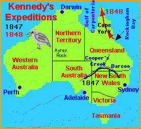 Edmund Kennedy (1818-1848) was an explorer and the Assistant-Surveyor of New South Wales, Australia. Kennedy explored the interior of Queensland, Australia, including the Thomson River, the Barcoo River, Cooper’s Creek, and the Cape York Peninsula.

Kingsley, MaryMary Henrietta Kingsley (1862-1900) was a British explorer who made two pioneering trips to West and Central Africa. She was the first European to enter remote parts of Gabon.
 Richard Lemon Lander (1804-1834) was an English explorer who made three trips to West Africa; he and his brother John were the first Europeans to canoe down the lower Niger River to its delta (where it meets the sea).
David Livingstone (1813-1873) was a British missionary and explorer who explored the interior of Africa. He arrived as a missionary in Africa in 1841, but began to explore the land in 1853. For over two decades he traveled over land, walking across the continent, and exploring the Zambezi River. He searched for the source of the Nile River. Livingstone was the first European to see the enormous Victoria Falls. Livingstone was thought to be dead (because of rumors started by deserters of his expedition), but the American reporter Henry M. Stanley was sent to Africa to find Livingstone. Stanley found him (1872) and brought him needed food and medicine, then left to recount the tale to readers. Livingstone died a year later in Africa; his heart was buried there, but his body was buried in Westminster Abbey, London, England, after an 8-month journey.
Sir Thomas Livingstone Mitchell (1792- October 5, 1855) was an explorer, surveyor and author who led four surveying expeditions into southeastern Australia. Mitchell’s expeditions surveyed west of Sydney; he explored northern and western New South Wales, the Darling River system, and surrouding areas.
Mitchell was born in Craigend, Scotland. After serving in the British Army and surveying in Spain, he sailed to Sydney, Australia, in 1827. In Sydney, Mitchell was the deputy surveyor general (serving under John Oxley). He was knighted in 1839.
John Joseph William Molesworth Oxley (1785? - 1828) was an explorer and surveyor who explored areas of eastern Australia and Tasmania; he also collected geological information. Oxley was the surveyor-general of New South Wales, Australia.
Oxley was born in England, and sailed to Australia in 1802 while in the British Navy. For years, he surveyed the coast of Australia, then in 1806 he commanded a ship to Van Diemen’s Land (later called Tasmania).
After returning to England and being promoted to lieutenant, Oxley sailed to Australia (1808). He was granted 600 acres (240 hectares) of land in Sydney and was appointed surveyor-general of New South Wales. He continued his surveys of Australia, including: the Lachlan River region (with George Evans, 1817), the Macquarie River (1818), Jervis Bay and Port Macquarie (1819), Moreton Bay and 50 miles (80 km) up the Brisbane River (1823).

 Zebulon Montgomery Pike (January 5, 1779 - April 27, 1813) was an American explorer and military officer (he served in the War of 1812). Pike tried to find the source of the Mississippi River; he also explored the Rocky Mountains and southwestern North America. Pike’s Peak in Colorado is named for him.

John Rae (1813-1893) was a Scottish explorer, surveyor, and surgeon who explored the Canadian Arctic. Rae made three voyages, in 1848-1849, 1851, and 1853-1854, to find the Arctic explorer Sir John Franklin, who had disappeared together with his Arctic expedition. Rae surveyed and mapped over 1,400 miles (2255 km) of uncharted Canadian coastline. He also showed that King William Land was an island. On his third journey, Rae determined that Franklin and his expedition had died of starvation and exposure in the Arctic; Eskimos at Pelly Bay told Rae of Franklin’s fate. During his Arctic expeditions, the hearty Rae walked over 23,000 miles (37000 km).

 Sir James Clark Ross (1800 - 1862) was a British explorer and naval officer who went on missions to both the Arctic and the continent of Antarctica, doing magnetic surveys.
The Arctic: Ross went on Arctic expeditions with Sir William E. Parry from 1819 to 1827. Ross and his uncle, Sir John Ross, located the north magnetic pole on Boothia Peninsula (in northern Canada, north of King William Island) on May 31, - June 1, 1831.
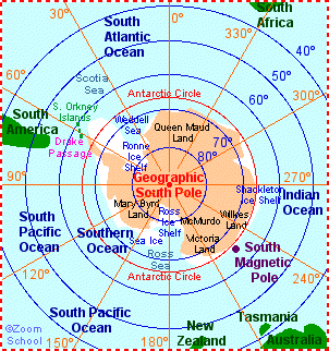
Antarctica: James Ross led an Antarctic expedition (1839-43), commanding the “Erebus” while his friend Francis Crozier commanded the “Terror.” Ross charted much of the coastline and in 1841 discovered the Ross Sea, and the Victoria Barrier, which was later renamed the Ross Ice Shelf.

Sacajawea, also spelled Sacagawea (1788-1812) was a Shoshone Indian who guided, and acted as interpreter and negotiator for Meriwether Lewis and William Clark on their exploratory expedition. She traveled with them from North Dakota to the Oregon coast and back.

Jedediah Smith (1798-1831) was an American mountain man, hunter, trapper, and explorer. Smith was from New York and was the first European American to reach California overland from the east (though the Rocky Mountains and the Mojave Desert). He was also the first European American to cross the Great Basin Desert via the Sierra Nevada Mountains and the Great Salt Lake (on his return from California). During this trip, the heat was so unbearable that Smith and his men resorted to burying themselves in the sand during the hottest parts of the day. Smith was killed by Comanche Indians on the Santa Fe Trail near the Cimarron River in 1831. His body was never found. Smith never published an account of his travels, so little is known about them.
David Thompson (1770-1857) was a Welsh explorer (born in London, England); Thompson’s family name was originally as Tomos. Thompson was also a mapmaker, surveyor, fur trader, and journal writer. . Thompson explored western North America, including what is now western Canada and the western USA. Thompson was the first European to explore the entire length of Columbia River. Thompson’s detailed maps of western North America were the first ones made, and were the basis of maps for years to come. Thompson began working as a clerk for the Hudson’s Bay Company in 1784. In 1796, Thompson explored Lake Athabasca. In 1797, Thompson joined and become a partner in the North West Company (a rival trapping company). In 1797-1798, Thompson went on an expedition down the Missouri River; he discovered Turtle Lake, one of the headwaters of the Mississippi River, in 1798. In 1807, Thompson crossed the Rocky Mountains and built the first trading post on the Columbia River. From 1818 to 1826, Thomson surveyed the border between Canada and the USA.

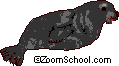 James Weddell (1787 -1834) was an English explorer, naturalist, geographer, and sealer who sailed on three expeditions to the Antarctic (in the years 1820-21, 1821-22 and 1822-23). Captain Weddell sailed on the brig “Jane.” On these sealing/scientific expeditions, Weddell discovered the Weddell Sea (near the South Pole) and the Weddell Seal, Leptonychotes weddelli in 1823. Weddell sealCaptain Weddell also set an 80-year record for the farthest southern latitude reached (74°15’S, set February 20, 1823). Weddell wrote of his adventures in the book, “A Voyage Towards the South Pole in the Years 1822-24” (published in 1825). Weddell died in poverty at the age of 47.
Sir Francis Younghusband (1863-1942) was an English explorer and Army officer who went on many expeditions to the Himalayan Mountains and Tibet.
Younghusband was born in India to British parents, and was educated in England. His first expedition to the Himalayas was in 1884, when he went to Afghanistan and Kashmir for the British Army. In 1886, he went to Manchuria, China, and returned to India overland with Colonel Mark Bell. They traveled over 1,250 miles (they split up for part of the journey), crossing the Gobi Desert, the Taklamakan Desert, the Karakorum Mountains, and the Himalayas, returning to India at Rawalpindi.
In 1889, Younghusband returned to the Karakorum Mountains for the Army and later became an official of the Indian Foreign Department in order to stop the Russians (who were exploring the border regions near Afghanistan and Tadzhikistan). In 1890, he traveled with Sir George McCartney on a diplomatic trip to central Asia. Leading an anti-Russian 1903 trip to Tibet, Younghusband was accompanied by 3,000 troops commanded by Sir James MacDonald. Along the way, they explored the Brahmaputra River and the Sutlej River.
Younghusband wrote of his adventures in the books: Heart of a Continent (1896), India and Tibet (1910), and The Epic of Mount Everest (1926).