USA & Printouts & 5th Grade
Add Filters
Add Filters
Subjects
USA
Page Types
Printouts
Awards
(1)
Bookmarks
(0)
Books
(14)
Gift Tags
(0)
Graphic Organizers
(64)
Name Tags
(1)
Word Wheels
(1)

US State Capitals Label Me! Printout.

Label Midwestern US State Capitals Printout.
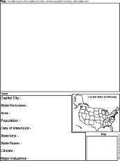
US State Report Diagram Printout: Thiss chart is used to write a short US state report, including a hand-drawn map and...
★
Full access for members only.
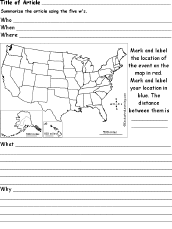
US Map Chart Printout: 5 W's labeled sections around a main oval, labeled, Who, When, What, Where, and Why.
★
Full access for members only.

USA (Contiguous) Latitude and Longitude Activity: Printout #1.
US States and their Capitals Printout.

USA Regional Map/Quiz Printouts.

Outline Map of US Rivers Labeled. An outline of US rivers.
USA Latitude and Longitude Activity: Printout #2.

Outline Map of the US States (numbered). An outline of the US with state borders.
| Previous Page | Page 2 of 26 | Next Page |