North America
Add Filters
Add Filters
Page Types
Activities & Fun
(1000+)
Crafts
(347)
Printouts
(1000+)
Quizzes
(1000+)
References & Studying
(1000+)
Teacher Resources
(337)
Worksheets
(1000+)
Grade Levels
Work in Progress - Not all pages are categorized yet
Preschool
(92)
Kindergarten
(969)
1st Grade
(1000+)
2nd Grade
(1000+)
3rd Grade
(1000+)
4th Grade
(1000+)
5th Grade
(830)
6th Grade
(278)
7th Grade and Up
(97)

North Dakota State Map/Quiz Printout.

Matthew Henson (1866 - 1955) was an African-American explorer and one of the first people to visit the North Pole.
Samuel de Champlain (1567?-1635) was a French explorer/navigator who mapped much of northeastern North America.


Outline Map North Korea: A collection of geography pages, printouts, and activities for students.

North Carolina State Map/Quiz Printout.
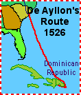
Explorers of North America
The Flag of Jamaica. This flag was adopted on August 6, 1962.
Canadian Provinces and Territories. Canada has 10 provinces and 3 territories: Alberta (Edmonton), British Columbia...
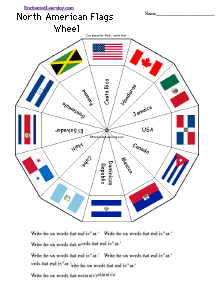
North American Flags Wheel - Bottom: Make and then use the wheel to make Flags of Europe appear, including: USA, Canada...
★
Full access for members only.
| Previous Page | Page 5 of 990 | Next Page |