
|
| You might also like: | Saudi Arabia | Bangladesh | Indonesia | Vietnam | Iran | Today's featured page: Bat Connect-the-Dots |
Capital: Islamabad is the capital of Pakistan.
Size: Pakistan covers about 796,095 square kilometers (about twice as big as the state of California). Pakistan is the 36th largest country in the world.
Population: The people of Pakistan are called Pakistanis. Pakistan has the 6th largest population of any country in the world (after China, India, USA, Indonesia, and Brazil). The population of Pakistan is about 184,404,791 (as of July, 2010).
Government: Pakistan is a republic that is divided into 4 provinces, 1 territory, and 1 capital territory. The National Holiday is Republic Day, celebrated on March 23. Independence Day is celebrated on August 14 (Pakistan became independent from India on August 19, 1947).
Language: The official language is Urdu (spoken by about 8% of the population). Major languages include Punjabi 48%, Sindhi 12%, Siraiki (a variant of Punjabi) 10%, Pashtu 8%, etc.
Education: Girls in Pakistan go to school for an average of 6 years; boys go for an average of 8 years.
Literacy Rate: Just under 50% (half) of the adults in Pakistan can read and write. About 63% of the men and 36% of the women are literate.
Official Religion: Islam (95% of the people of Pakistan are Muslim; 75% Sunni Muslim and 20% Shia Muslim). Minority religions include Christian and Hindu.
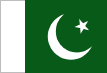
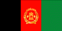
The Pakistani flag is green and white. A white crescent moon and a five-pointed star are on a green field; a white stripe by the hoist side represents the nation's minority non-Muslim population. The crescent and star are traditional symbols of the Islamic religion. The star symbolizes light and knowledge; the crescent moon symbolizes progress. The height of this flag is two-thirds the width.
Major Rivers: The Indus River flows through Pakistan to the Arabian Sea.
Terrain/Mountain Ranges: The Hindu Kush Mountains are a mountain range in the north of Pakistan. The flat Indus plain is in the east and the high Balochistan plateau is in the west.
Highest Point: The highest point in Pakistan is K2 (also called Mt. Godwin-Austen), which is 8,611 m above sea level; it is located in the northeastern Pakistan.
Lowest Point: The lowest point in Pakistan is the Indian Ocean, at sea level.
Natural Resources: Natural gas, limited petroleum, poor quality coal, iron ore, copper, salt, limestone
Major Industries: Textiles and apparel, food processing, pharmaceuticals, construction materials, paper products, fertilizer, shrimp.
Agricultural Products: Cotton, wheat, rice, sugarcane, fruits, vegetables; milk, beef, mutton (lamb), eggs.

Pakistan's FlagEnchantedLearning.com
All About Pakistan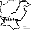
Map/Quiz Printout
Location: Pakistan (officially called the Islamic Republic of Pakistan) is a country in southwestern Asia (in the Middle East). Pakistan is bordered by Iran, Afghanistan, China, India, and the Arabian Sea.

 Pakistan's Flag: Pakistan's flag was adopted on August 14, 1947, when Pakistan became an independent Muslim state, no longer part of Great Britain. The flag was designed by Ali Jinnah, who founded Pakistan.
Climate: Pakistan's is mostly hot, dry desert. The northwest is cooler (temperate) and the high-altitude north is very cold (arctic).
Related Activities and Printouts:
Pakistan: Outline Map Printout An outline map of Pakistan to print. |
Pakistan: Map Quiz Worksheets Go to printable worksheets that require geography research (using an atlas or other geography reference): a simple map research activity, a medium-level map research activity, or an advanced map research activity. |
 Pakistan: Follow the Instructions Color Pakistan according to simple directions, such as, "Color Pakistan yellow." Or go to the answers. |
 Flag of Pakistan to Color Color a blackline master (printout) of the flag of Pakistan. |
 Flag of Pakistan A page on the flag plus a quiz to print. |
 Asia: Outline Map Printout An outline map of Asia to print. |
 Asia: Label Me! Printout Label the map of Asia. Answers |
 Middle East Geography Pages on the geography of the Mideast. |
 Middle East Map: Label Me! Printout Label a map of the Middle East. Answers |
 Middle East: Outline Map Printout An outline map of the Middle East to print. |
Reference:
CIA World Factbook
Enchanted Learning®
Over 35,000 Web Pages
Sample Pages for Prospective Subscribers, or click below
|
Overview of Site What's New Enchanted Learning Home Monthly Activity Calendar Books to Print Site Index K-3 Crafts K-3 Themes Little Explorers Picture dictionary PreK/K Activities Rebus Rhymes Stories Writing Cloze Activities Essay Topics Newspaper Writing Activities Parts of Speech Fiction The Test of Time
|
Biology Animal Printouts Biology Label Printouts Biomes Birds Butterflies Dinosaurs Food Chain Human Anatomy Mammals Plants Rainforests Sharks Whales Physical Sciences: K-12 Astronomy The Earth Geology Hurricanes Landforms Oceans Tsunami Volcano |
Languages Dutch French German Italian Japanese (Romaji) Portuguese Spanish Swedish Geography/History Explorers Flags Geography Inventors US History Other Topics Art and Artists Calendars College Finder Crafts Graphic Organizers Label Me! Printouts Math Music Word Wheels |
Click to read our Privacy Policy
| Search the Enchanted Learning website for: |