
|
| You might also like: | Outline Map of Greenland | H: GEOGRAPHY | Germany - Follow the Instructions | Outline Map: Greece | Label the Lower-Case Greek Alphabet | Today's featured page: Fact or Opinion? Butterflies, A Worksheet |
| Our subscribers' grade-level estimate for this page: 4th - 5th |
 Outline Maps |
EnchantedLearning.com World Geography |
 Flags |
| Africa | Antarctica | Asia | Australia/Oceania | Central America/ Caribbean | Europe | Mideast | North America | South America | USA |
| A | B | C | D | E | F | G | H | I | J | K | L | M | N | O | P | Q | R | S | T | U | V | W | X | Y | Z |
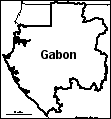 Gabon: Outline Map Printout An outline map of Gabon to print. Or go to printable worksheets that require research (using an atlas or other geography reference): a simple map research activity, a medium-level map research activity, or an advanced map research activity. |
 Gambia, The: Outline Map Printout An outline map of Gambia to print. |
Geography Crafts and Activities These are crafts that help you learn geography. |
 Geography: Label Me! - Printouts Print out and label many maps of Continents, oceans, US states, and Canadian provinces. |
 Geography Word Anagrams This is a word bank of anagrams of geography words. An anagram is a word or phrase that is made by rearranging the letters of another word or phrase. For example, latitude is an anagram of altitude. |
Look It Up! Geography Quiz To find the answer to the 20 questions on this printable geography quiz, look up the words in the Little Explorers picture dictionary. Or go to the answers. |
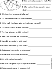 Geography Quiz A Worksheet to Print A short, printable worksheet quiz about world geography. The short-answer worksheet asks 15 general questions about the earth's continents and oceans, for example, "On which continent do you live?" Or go to the answers. |
 Find a Geography Word for Each Letter See if you can think of and write down a place name that starts with each letter of the alphabet. Or go to a sample answer page. |
 Geography Word Pieces Puzzle In this puzzle, combine pairs of word segments to make geography-related spelling words. Words: compass, country, east, latitude, legend, longitude, meridian, map, north, scale, south, west. Or go to the answers. |
eastern earnest nearest plane Geography Anagrams A web page with geography terms that are anagrams. Some examples include: latitude/altitude, nation/anoint, region/ignore. |
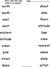 Geography Anagrams - Matching Draw a line from each geography-related word to its anagram. Words: north/thorn, south/shout, east/sate, west/stew, eastern/nearest, latitude/altitude, ocean/canoe, pole/lope, strait/artist, lakes/slake. Or go to the answers. |
 Geography Anagram Puzzle Worksheet On this printable worksheet, the student writes a geography anagram for each word. Or go to the answers |
 Georgia Georgia is a state in the southeastern United States of America. Its capital is Atlanta. Map, flag, symbols, printouts, and quizzes. |
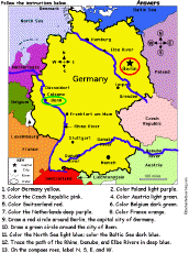 Germany: Follow the Instructions Color Germany according to simple directions, such as, "Draw a red circle around Berlin, the capital city of Germany." Or go to the answers. |
 Germany: Label Me! Map Printout Label the map of Germany. Answers |
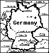
 Germany: Outline Map Printout An outline map of Germany to print. Or go to printable worksheets that require research (using an atlas or other geography reference): a simple map research activity, a medium-level map research activity, or an advanced map research activity. |
 Germany: Dot to Dot Mystery Map Connect the dots to draw the borders of a mystery country. Then use a globe or atlas to figure out which country you have drawn. You might want to give students clues, such as the continent the country is in (Europe), that it is in the Northern Hemisphere, or that its name starts with "G." Answer: Germany. |
 German Theme Page Information, quizzes, and printouts. |
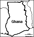 Ghana: Outline Map Printout An outline map of Ghana to print. Or go to printable worksheets that require research (using an atlas or other geography reference): a simple map research activity, a medium-level map research activity, or an advanced map research activity. |
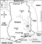 Ghana: Map Quiz Worksheet A printable quiz on the major geographic features of Ghana. The student reads a map to answer 10 geography questions. Or go to the answers. |
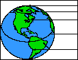 Label the Globe in English Label the globe in English, including the North Pole, Arctic Circle, Northern Hemisphere, equator, Southern Hemisphere, and South Pole. Answers |
Label the Globe in French Label the globe in French, including the North Pole, Arctic Circle, Northern Hemisphere, equator, Southern Hemisphere, and South Pole. Answers |
Label the Globe in German Label the globe in German, including the North Pole, Arctic Circle, Northern Hemisphere, equator, Southern Hemisphere, and South Pole. Answers |
Label the Globe in Italian Label the globe in Italian, including the North Pole, Arctic Circle, Northern Hemisphere, equator, Southern Hemisphere, and South Pole. Answers |
Label the Globe in Spanish Label the globe in Spanish, including the North Pole, Arctic Circle, Northern Hemisphere, equator, Southern Hemisphere, and South Pole. Answers |
 Glossary of Landforms Learn terms describing land and water forms on Earth. |
 Great Britain: Outline Map Printout An outline map of UK to print. Or go to printable worksheets that require research (using an atlas or other geography reference): a simple map research activity, a medium-level map research activity, or an advanced map research activity. |
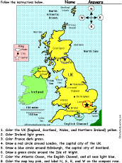 United Kingdom of Great Britain and Northern Ireland: Follow the Instructions Color the United Kingdom of Great Britain and Northern Ireland according to simple directions, such as, "Draw a red circle around Edinburgh, the capital city of Scotland." Or go to the answers. |
 Great Lakes The Great Lakes are five huge, connected lakes located between Canada and the USA. The lakes are (from biggest to smallest) Lake Superior, Lake Michigan, Lake Huron, Lake Erie, and Lake Ontario. These lakes were formed by glaciers during the last Ice Age. |
 Great Wall of China Information on the Great Wall of China. |
 Greece Geography, maps, the flag, and printouts on Greece. |
 Greece: Follow the Instructions Color Greece according to simple directions, such as, "Draw a red circle around Athens, the capital city of Greece." Or go to the answers. |
 Greece: Tab Book A book about Greece for fluent readers with pages on the map, flag, language, Ancient Greece, the Olympics, and the Greek Gods and Mount Olympus. |
 Greece: Outline Map Printout An outline map of Greece to print. Or go to printable activities that require research (using an atlas or other geography reference): a simple map research activity, a medium-level map research activity, or an advanced map research activity. |
 Greenland: Outline Map Printout An outline map of Greenland to print. |
 Guatemala: Outline Map Printout An outline map of Guatemala to print. Or go to printable worksheets that require research (using an atlas or other geography reference): a simple map research activity, a medium-level map research activity, or an advanced map research activity. |
 Guinea: Outline Map Printout An outline map of Guinea to print. |
 Guyana: Outline Map Printout An outline map of Guyana to print. |
| EnchantedLearning.com World Geography |
Flags |
| Africa | Antarctica | Asia | Australia/Oceania | Central America/ Caribbean | Europe | Mideast | North America | South America | USA |
| A | B | C | D | E | F | G | H | I | J | K | L | M | N | O | P | Q | R | S | T | U | V | W | X | Y | Z |
Enchanted Learning®
Over 35,000 Web Pages
Sample Pages for Prospective Subscribers, or click below
|
Overview of Site What's New Enchanted Learning Home Monthly Activity Calendar Books to Print Site Index K-3 Crafts K-3 Themes Little Explorers Picture dictionary PreK/K Activities Rebus Rhymes Stories Writing Cloze Activities Essay Topics Newspaper Writing Activities Parts of Speech Fiction The Test of Time
|
Biology Animal Printouts Biology Label Printouts Biomes Birds Butterflies Dinosaurs Food Chain Human Anatomy Mammals Plants Rainforests Sharks Whales Physical Sciences: K-12 Astronomy The Earth Geology Hurricanes Landforms Oceans Tsunami Volcano |
Languages Dutch French German Italian Japanese (Romaji) Portuguese Spanish Swedish Geography/History Explorers Flags Geography Inventors US History Other Topics Art and Artists Calendars College Finder Crafts Graphic Organizers Label Me! Printouts Math Music Word Wheels |
Click to read our Privacy Policy
| Search the Enchanted Learning website for: |
Copyright ©2002-2018 EnchantedLearning.com ------ How to cite a web page